
“The Hayward Fault – Is it Due for a Repeat of the Powerful 1868 Earthquake?” by the U.S. Geological Survey (USGS) view document | go to usgs.gov website
“Earthquake Safety for Homeowners” by the Federal Emergency Management Agency (FEMA 530) view document | go to fema.gov website
“Putting down roots in Earthquake Country – Northern CA” by the United States Geological Society (USGS) view document | go to earthquakecountry.info website
http://www.mercurynews.com/science/ci_25793975/quake-cluster-likely-strike-bay-area-scientist-say
Websites:
“Earthquake Cluster Likely to Strike Bay Area,” an article from the San Jose Mercury News about the likelihood of a cluster of earthquakes striking the Bay Area. http://www.mercurynews.com/science/ci_25793975/quake-cluster-likely-strike-bay-area-scientist-say
“Celebrating Earthquake Safety,” a resource regarding earthquake safety, why buildings fail, and how earthquakes affect different buildings. http://www.celebratingeqsafety.com/why-buildings-fail.html
“Community Action Plan for Seismic Safety,” a report and ongoing committee by the San Francisco Department of Building Inspection http://www.sfcapss.org
“The Resilient City,” a report and ongoing committee by the San Francisco Planning and Urban Research Association (SPUR) http://www.spur.org/publications/library/report/theresilientcity_part1_020109
Seismic Hazard Zone Maps – Northern California. Maps indicating zones of potential earthquake-induced liquefaction and landsliding http://gmw.consrv.ca.gov/shmp/html/pdf_maps_no.html
Association of Bay Area Governments http://quake.abag.ca.gov
United States Geological Survey http://earthquake.usgs.gov/learning
Ground Shaking Simulations: Courtesy of the United States Geological Survey (USGS)
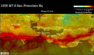
1906 Ground Motion Simulation “This computer simulation was created by seismologists at the USGS, in order to better understand the distribution of shaking and damage that happened in the 1906 earthquake, and help predict ground shaking intensity and damage to structures in future earthquakes. Yellow to red colors indicate regions experiencing damaging shaking.” (paraphrased by R. Collins
download video (requires QuickTime Player) Download QuickTime Player
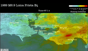
1989 Ground Motion Simulation “The 1989 Loma Prieta simulation was created to validate the computer model of the 1906 event, by comparing the 1989 simulation with scientific data obtained from instrumental observations” (such as seismograms and accelerometers).
download video (requires QuickTime Player) Download QuickTime Player “One striking observation for those who experienced the 1989 Loma Prieta earthquake’s shaking is the comparison of the extent and intensity of shaking with the 1906 earthquake. The Loma Prieta rupture was about 30 times smaller in energy than the great 1906 earthquake.”
If the 1906 earthquake is equated to an auto accident at 75 mph, then the Loma Prieta quake would equal an accident at 13 mph. Feeling secure in future severe earthquakes because of the 1989 experience is like believing seat belts are not needed on the highway because of surviving a parking lot fender-bender.
All quotations are from the USGS website. More information is available at the USGS website: http://earthquake.usgs.gov/regional/nca/simulations/
Base Isolation Simulation:
Base isolation is a design used in earthquake engineering to minimize the impact of an earthquake on a structure by lowering its accelerations and displacements. Below is a video courtesy of the UC San Diego Englekirk Structural Engineering Center. The multistory building sits on rubber base isolators used to absorb the energy of the earthquake and lower the impact of the earthquake on the structure. Note the movement of the ground relative to that of the structure, similar to a building sitting on marbles.